


Sedimentology and Stratigraphy
The Holden NE distributary system is a unique sedimentary structure on Mars. The well-preserved nature of channels and layered outcrops exposed in this landform is unparalleled among known geologic features on Mars. This fact allows for a more rigorous and quantitative approach to geomorphologic interpretation than is often possible on Mars. This process is aided by high resolution imagery from the Mars Orbiter Camera (MOC), in orbit around Mars since 1997. We have used pairs of MOC images, in stereo, to derive high-resolution topographic information about the layered deposits in Holden NE crater. Using this data, we have found evidence that the distributary network was once a delta emptying into a lake on the floor of Holden NE crater. Below is a 3D view of the layered outcrops along the edge of this ancient delta, which shows a MOC image draped over the stereo-derived topographic data.

Flythrough movie (QuickTime or AVI format)
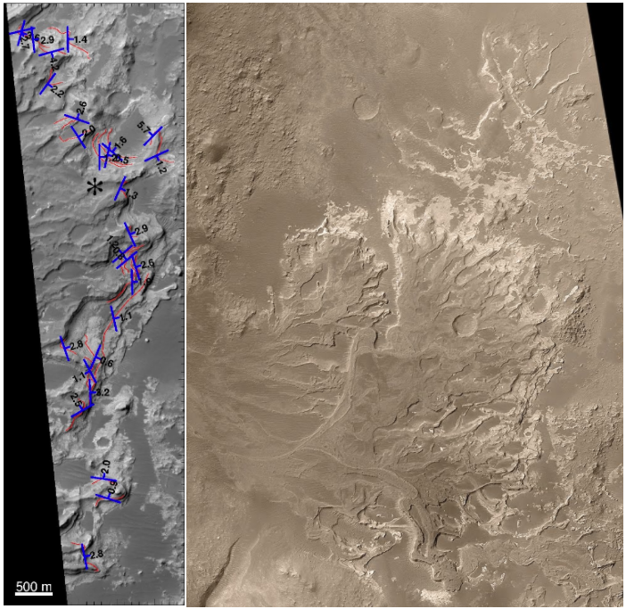
A key aspect of geomorphologic interpretation of a layered geologic sequence lies in understanding the orientation of the layers exposed in an outcrop. This measurement aids in distinction between various methods of formation, and in detection of post-depositional deformation and tilting. We have used a stereo-derived Digital Elevation Model (DEM) to assess the orientation of many of the layers exposed in the Holden NE deposit. The image on the left below shows the strike and dip measurements (blue marks and corresponding figures) for the layers used in our analysis. Red lines show the trace of the layers. These measurements have revealed a complex internal structure, not obvious in imagery alone. However, trends can be seen among several layers. One such area where strike measurements are correlated among several layers is denoted by '*'. The image on the right is a MOC mosaic of the entire Holden NE distributary network, created by Malin Space Science Systems.
References
- Lewis K.W., Aharonson O., Occurrence and origin of rhythmic sedimentary rocks on Mars, J. Geophys. Res. Planets, 119 (6), 1432-1457, 2014. [DOI: 10.1002/2013JE004404]
- Lewis K.W., Aharonson O., Grotzinger J.P., Kirk R.L., McEwen A.S., Suer T.-A., Quasi-periodic bedding in the sedimentary rock record of Mars, Science, 322 (5907), 1532-1535, 2008. [DOI: 10.1126/science.1161870]
- Lewis K.W., Aharonson O., Grotzinger J.P., Squyres S.W., Bell III J F., Crumpler L.S., Schmidt M.E., Structure and stratigraphy of Home Plate from the Spirit Mars Exploration Rover, J. Geophys. Res. Planets, 113, E12S36, 2008. [DOI: 10.1029/2007JE003025]
- Lewis K.W., Aharonson O., Stratigraphic analysis of the distributary fan in Eberswalde crater using stereo imagery, J. Geophys. Res. Planets, 111, E06001, 2006. [DOI: 10.1029/2005JE002558]
More information about this and other research is available in the form of published manuscripts here.
Mars Exploration Rover
Soil Structure and Stratifcation as Indicators of Aqueous Transport at the MER Landing Sites
 |
 |
| Fig. 1. Spirit: Gusev Crater. Image Credit: NASA/JPL/Cornell. |
Fig. 2. Opportunity: Meridiani Planum. Color processing by M. Lyle. Image Credit: NASA/JPL/Cornell. |
NASA's twin robot geologists, the Mars Exploration Rovers, launched toward Mars in June 10 and July 2003, in search of answers about the history of water on Mars. They landed on Mars January 3 and January 24 PST (January 4 and January 25 UTC). The mission is part of NASA's Mars Exploration Program, a long-term effort of robotic exploration of the red planet.
Primary among the mission's scientific goals is to search for and characterize a wide range of rocks and soils that hold clues to past water activity on Mars. The spacecraft are targeted to sites on opposite sides of Mars that appear to have been affected by liquid water in the past. The landing sites are at Gusev Crater, a possible former lake in a giant impact crater, and Meridiani Planum, where mineral deposits (hematite) suggest Mars had a wet past.
What is the nature of stratified soils at the MER landing sites?
What is the role of water in transporting cementing agents to more cohesive units?
What is the spatial extent of such layers?
Motivated by the potential role of liquid, thin films, and vapor in the transport of water and associated solutes, the broad objectives of our investigation are to describe the vertical structure of the landing site soils, to characterize surface seals or crusts, and to constrain the chemical and/or physical processes that lead to their formation.
References
- Lewis K.W., Aharonson O., Grotzinger J.P., Squyres S.W., Bell III J F., Crumpler L.S., Schmidt M.E., Structure and stratigraphy of Home Plate from the Spirit Mars Exploration Rover, J. Geophys. Res. Planets, 113, E12S36, 2008. [DOI: 10.1029/2007JE003025]
- Diez B., W.C. Feldman, S. Maurice, O. Gasnault, T.H. Prettyman, M.T. Mellon, O. Aharonson, N. Schorghofer, H layering in the top meter of Mars, Icarus, 196, 409–421, 2008. [DOI: 10.1016/j.icarus.2008.02.006]
- Rogers A.D., Aharonson O., Mineralogical composition of sands in Meridiani Planum determined from Mars Exploration Rover data and comparison to orbital measurements, J. Geophys. Res. Planets, 113, E06S14, 2008. [DOI: 10.1029/2007JE002995]
- Squyres S.W., Aharonson O., Arvidson R.E., Bell III J.F., Christensen P.R., Clark B.C., Crisp J.A., Farrand W., Glotch T., Golombek M.P., Grant J., Grotzinger J., Herkenhoff K.E., Johnson J.R., Jolliff B.L., Knoll A.H., McLennan S.M., McSween H.Y., Moore J.M., Rice Jr. J.W., Tosca N., Bedrock formation at Meridiani Planum, Nature, 443, E1-E2, 2006. [DOI: 10.1038/nature05212]